|
|
Post by JohnV on Aug 18, 2019 9:07:16 GMT
|
|
Deleted
Deleted Member
Posts: 0
|
Post by Deleted on Aug 18, 2019 9:09:15 GMT
Muddy ditches are much, much easier  Rog |
|
|
|
Post by ianali on Aug 18, 2019 9:15:14 GMT
Muddy ditches are much, much easier Rog It is interesting having to work with tides and currents though. Ali and me have considered a coastal type boat, sailing maybe. Would miss the cut very much though. |
|
|
|
Post by JohnV on Aug 18, 2019 9:19:35 GMT
Muddy ditches are much, much easier Rog It is interesting having to work with tides and currents though. Ali and me have considered a coastal type boat, sailing maybe. Would miss the cut very much though. Know what you mean ..... I love both ..... in fact I enjoy almost every form of boating I have ever tried ...... except for doing it for a living deep sea  p.s. and even that was good for the first few years |
|
|
|
Post by patty on Aug 18, 2019 10:23:10 GMT
It is interesting having to work with tides and currents though. Ali and me have considered a coastal type boat, sailing maybe. Would miss the cut very much though. Know what you mean ..... I love both ..... in fact I enjoy almost every form of boating I have ever tried ...... except for doing it for a living deep sea p.s. and even that was good for the first few years I love boats and never pass up the opportunity to have a trip on different vessels..however think I wouldn't have like having to be on choppy seas for a living...I guess I'm mainly a fair weather calmish seas sorta person. Don't mind bit of bumpy weather but not stomach churning storm tossed seas in little boats. |
|
|
|
Post by TonyDunkley on Aug 18, 2019 15:32:53 GMT
If you're going on upriver in the next day or two there'll be plenty of water in the river all the way up and the only place you'll have to take extra care is passing Normanton Island, . it's smack in the middle of the river and submerged just below the surface for most of the time ! To get the maximum help from the tide as far up as possible, you'll need to be out of the end of Torksey Cut and on your way up just before Flood. The last mile or two up to Cromwell can be a long hard slog if there's a bit of fresh on and you're late on the tide. Will be going from Torksey to Cromwell probably Wednesday. Will obviously ring Torksey beforehand. However I’d like to learn more and be able to work out for myself the timings on the Trent, other tidal areas as well really. But where do you start? The effects of the tide on a river changes drastically as you move further inland from the estuary, and by the time you're up as far as Cromwell on the Trent, and Naburn on the Ouse, local HW is as much as 4 or 5 hours later than it was for the same tide at Hull. Compared with the Flood and Ebb periods of each tide at or near the coast - approximately 6(+) hours of each - the period of Flood shortens as the tide runs inland, and the period of Ebb lengthens correspondingly. Where you are now, at Torksey, for instance it ''runs up'' (Flood) for up to around 2 hours and "runs down'' (Ebb) for around 10 and a bit hours. There are 'rule of thumb' correction figures you can apply to the predicted HW times at the usual reference port to estimate the tide time at various places upriver. Hull is the usual port for both the Ouse and the Trent, but many other factors also influence the time and height of the tide both at the reference port and as it moves further inland, . . such as atmospheric pressure, wind strength and direction, and the amount of rainfall in the river's catchment are over the previous few days, and they have to be applied to the approximate arbitrary correction times according to the prevailing weather and river conditions on the day. As for learning how to working out tide, departure, and arrival times for trips on tidal rivers, . . the best way by far is to keep coming back and spending as much time on them as you possibly can. There are some 'rule of thumb' correction times for various places on the Trent in those Boating Association Charts that Nick offered to e-mail to you the other day, but for more reliable and accurate figures there's nothing to beat on the spot observations of the times and heights of the immediately preceding tides (ie. local HW and Flood and levels), noting how much depth over such as side lock cills the tide "made", and making notes of by how they vary from the published predicted times for the reference port as the (roughly) 14 day tidal cycle goes from Neaps to Springs and back to Neaps again. Tidal rivers and the effects of the tides is a very complex subject, something of a black art even, and the Gods of the rivers have a wicked sense of humour that can catch out even the most experienced. I first started learning about it, as a 12 year old lad, from tug and bargemen in the Hull trade working up to Nottingham or Selby and York, . . but that was nearly 60 years ago, . . and I'm still learning ! |
|
|
|
Post by ianali on Aug 18, 2019 20:44:57 GMT
Will be going from Torksey to Cromwell probably Wednesday. Will obviously ring Torksey beforehand. However I’d like to learn more and be able to work out for myself the timings on the Trent, other tidal areas as well really. But where do you start? The effects of the tide on a river changes drastically as you move further inland from the estuary, and by the time you're up as far as Cromwell on the Trent, and Naburn on the Ouse, local HW is as much as 4 or 5 hours later than it was for the same tide at Hull. Compared with the Flood and Ebb periods of each tide at or near the coast - approximately 6(+) hours of each - the period of Flood shortens as the tide runs inland, and the period of Ebb lengthens correspondingly. Where you are now, at Torksey, for instance it ''runs up'' (Flood) for up to around 2 hours and "runs down'' (Ebb) for around 10 and a bit hours. There are 'rule of thumb' correction figures you can apply to the predicted HW times at the usual reference port to estimate the tide time at various places upriver. Hull is the usual port for both the Ouse and the Trent, but many other factors also influence the time and height of the tide both at the reference port and as it moves further inland, . . such as atmospheric pressure, wind strength and direction, and the amount of rainfall in the river's catchment are over the previous few days, and they have to be applied to the approximate arbitrary correction times according to the prevailing weather and river conditions on the day. As for learning how to working out tide, departure, and arrival times for trips on tidal rivers, . . the best way by far is to keep coming back and spending as much time on them as you possibly can. There are some 'rule of thumb' correction times for various places on the Trent in those Boating Association Charts that Nick offered to e-mail to you the other day, but for more reliable and accurate figures there's nothing to beat on the spot observations of the times and heights of the immediately preceding tides (ie. local HW and Flood and levels), noting how much depth over such as side lock cills the tide "made", and making notes of by how they vary from the published predicted times for the reference port as the (roughly) 14 day tidal cycle goes from Neaps to Springs and back to Neaps again. Tidal rivers and the effects of the tides is a very complex subject, something of a black art even, and the Gods of the rivers have a wicked sense of humour that can catch out even the most experienced. I first started learning about it, as a 12 year old lad, from tug and bargemen in the Hull trade working up to Nottingham or Selby and York, . . but that was nearly 60 years ago, . . and I'm still learning ! Thanks again, interesting post. So...What’s a good time to leave Torksey this Wednesday to go up to Cromwell? |
|
|
|
Post by Telemachus on Aug 18, 2019 20:48:42 GMT
This is a useful chart: 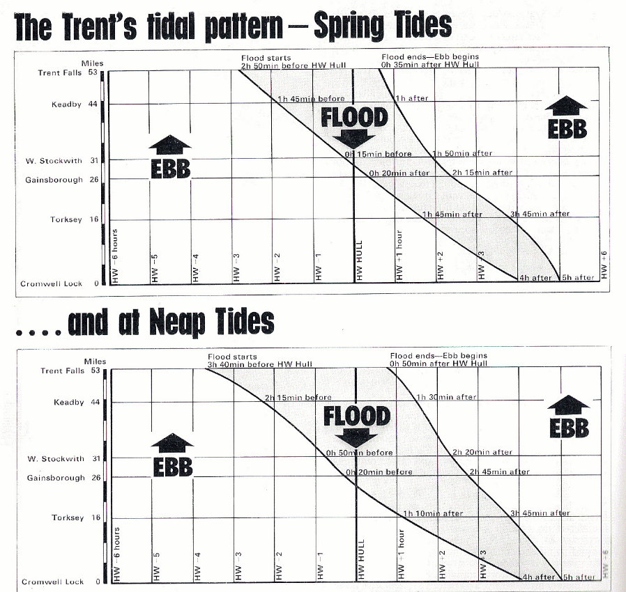 |
|
|
|
Post by Telemachus on Aug 18, 2019 20:50:08 GMT
|
|
|
|
Post by Telemachus on Aug 18, 2019 20:51:35 GMT
So around 11:45 (it’s between spring and neap). But really, set off as soon as the flood arrives. You know this because the level suddenly rises quite significantly.
There is quite a bit of fresh at the moment, but hopefully it will have diminished by Wednesday. We are planning to come up from Keadby to Torksey on Wednesday so we will just miss you!
|
|
|
|
Post by ianali on Aug 18, 2019 21:30:10 GMT
So around 11:45 (it’s between spring and neap). But really, set off as soon as the flood arrives. You know this because the level suddenly rises quite significantly. There is quite a bit of fresh at the moment, but hopefully it will have diminished by Wednesday. We are planning to come up from Keadby to Torksey on Wednesday so we will just miss you! So near yet so far. We have not set our schedule in stone so may bump into you on the Fossdyke. |
|
|
|
Post by Telemachus on Aug 18, 2019 21:39:54 GMT
So around 11:45 (it’s between spring and neap). But really, set off as soon as the flood arrives. You know this because the level suddenly rises quite significantly. There is quite a bit of fresh at the moment, but hopefully it will have diminished by Wednesday. We are planning to come up from Keadby to Torksey on Wednesday so we will just miss you! So near yet so far. We have not set our schedule in stone so may bump into you on the Fossdyke. We don’t have time for the Fossdyke (and went through to Boston a few years ago, so we’ve “done it”). We are sadly now in “going home mode” so after a journey break at Torksey it will be off up to Cromwell on the next daytime tide, Thursday lunchtime. |
|
|
|
Post by Trina on Aug 18, 2019 21:54:47 GMT
We went as far as Boston in 2017,really enjoyed it !
|
|
|
|
Post by duncan on Aug 18, 2019 22:27:48 GMT
The effects of the tide on a river changes drastically as you move further inland from the estuary, and by the time you're up as far as Cromwell on the Trent, and Naburn on the Ouse, local HW is as much as 4 or 5 hours later than it was for the same tide at Hull. Compared with the Flood and Ebb periods of each tide at or near the coast - approximately 6(+) hours of each - the period of Flood shortens as the tide runs inland, and the period of Ebb lengthens correspondingly. Where you are now, at Torksey, for instance it ''runs up'' (Flood) for up to around 2 hours and "runs down'' (Ebb) for around 10 and a bit hours. There are 'rule of thumb' correction figures you can apply to the predicted HW times at the usual reference port to estimate the tide time at various places upriver. Hull is the usual port for both the Ouse and the Trent, but many other factors also influence the time and height of the tide both at the reference port and as it moves further inland, . . such as atmospheric pressure, wind strength and direction, and the amount of rainfall in the river's catchment are over the previous few days, and they have to be applied to the approximate arbitrary correction times according to the prevailing weather and river conditions on the day. As for learning how to working out tide, departure, and arrival times for trips on tidal rivers, . . the best way by far is to keep coming back and spending as much time on them as you possibly can. There are some 'rule of thumb' correction times for various places on the Trent in those Boating Association Charts that Nick offered to e-mail to you the other day, but for more reliable and accurate figures there's nothing to beat on the spot observations of the times and heights of the immediately preceding tides (ie. local HW and Flood and levels), noting how much depth over such as side lock cills the tide "made", and making notes of by how they vary from the published predicted times for the reference port as the (roughly) 14 day tidal cycle goes from Neaps to Springs and back to Neaps again. Tidal rivers and the effects of the tides is a very complex subject, something of a black art even, and the Gods of the rivers have a wicked sense of humour that can catch out even the most experienced. I first started learning about it, as a 12 year old lad, from tug and bargemen in the Hull trade working up to Nottingham or Selby and York, . . but that was nearly 60 years ago, . . and I'm still learning ! Thanks again, interesting post. So...What’s a good time to leave Torksey this Wednesday to go up to Cromwell? Ian, if it is of any help;
To show Nick's workings and how he came up with that timing, using the links he posted; Looking at Hull tide tables on Wednesday 21st August; HW Hull is 10.13AM. The height of the tide, 6.82m, shows it is 4 days after the highest spring tide, and 4 days before the lowest neap tide, for the week.
The spring tidal pattern shows the flood at Torksey starts 1hr 45 after HW Hull. ie 11.58 The neap tidal pattern shows the flood at Torksey starts 1hr 10 after HW Hull. ie 11.23 The date is half way between springs and neaps so around half way between those 2 times will be when the flood starts, which is the time Nick posted. However, as Tony says, there are many variables which could change the timings a little.
|
|
|
|
Post by JohnV on Aug 19, 2019 5:36:37 GMT
The effects of the tide on a river changes drastically as you move further inland from the estuary, and by the time you're up as far as Cromwell on the Trent, and Naburn on the Ouse, local HW is as much as 4 or 5 hours later than it was for the same tide at Hull. Compared with the Flood and Ebb periods of each tide at or near the coast - approximately 6(+) hours of each - the period of Flood shortens as the tide runs inland, and the period of Ebb lengthens correspondingly. Where you are now, at Torksey, for instance it ''runs up'' (Flood) for up to around 2 hours and "runs down'' (Ebb) for around 10 and a bit hours. There are 'rule of thumb' correction figures you can apply to the predicted HW times at the usual reference port to estimate the tide time at various places upriver. Hull is the usual port for both the Ouse and the Trent, but many other factors also influence the time and height of the tide both at the reference port and as it moves further inland, . . such as atmospheric pressure, wind strength and direction, and the amount of rainfall in the river's catchment are over the previous few days, and they have to be applied to the approximate arbitrary correction times according to the prevailing weather and river conditions on the day. As for learning how to working out tide, departure, and arrival times for trips on tidal rivers, . . the best way by far is to keep coming back and spending as much time on them as you possibly can. There are some 'rule of thumb' correction times for various places on the Trent in those Boating Association Charts that Nick offered to e-mail to you the other day, but for more reliable and accurate figures there's nothing to beat on the spot observations of the times and heights of the immediately preceding tides (ie. local HW and Flood and levels), noting how much depth over such as side lock cills the tide "made", and making notes of by how they vary from the published predicted times for the reference port as the (roughly) 14 day tidal cycle goes from Neaps to Springs and back to Neaps again. Tidal rivers and the effects of the tides is a very complex subject, something of a black art even, and the Gods of the rivers have a wicked sense of humour that can catch out even the most experienced. I first started learning about it, as a 12 year old lad, from tug and bargemen in the Hull trade working up to Nottingham or Selby and York, . . but that was nearly 60 years ago, . . and I'm still learning ! Thanks again, interesting post. So...What’s a good time to leave Torksey this Wednesday to go up to Cromwell? before travelling on the raging river where you may be attacked by all manner of evils, it is important to do your research  Don't despair at the complexities of the spells. Help is always at hand from those wise in the way of things you need to be wise about  Always remember to make the correct offerings to the gods before venturing forth as many dangers lurk out there  |
|