|
|
Post by NigelMoore on Aug 4, 2018 18:03:38 GMT
There is in fact, if I recall correctly, a specific option for boaters to disregard byelaws if compliance would endanger their vessel, which is interesting - I will look it up, but have no time now as I have promised to take some guests boating in 20 minutes. “ 18. The master of every vessel in obeying and construing these Byelaws shall have due regard to all dangers of navigation and collision and to any special circumstances, including the limitations of the craft involved, which may render a departure from the Byelaws necessary in order to avoid immediate danger.” Seems a sensible clause to have included, however it, along with everything else in the 1957 Byelaws was abolished and replaced – missing out this one sadly. |
|
|
|
Post by NigelMoore on Aug 4, 2018 18:13:01 GMT
It was an enjoyable trip – apart from breaking down within a mile from home and having to punt the boat to the nearest riverside pub where it will have to remain overnight until I can tow it back tomorrow. The couple who came with us had never been on a narrowboat before, and it had been on their bucket list. Chris turned out to have a better feel for steering than her husband, which she was very smug about. I was delighted to come across an amphibious car enroute; I have seen the Dutton in boat shows, but never seen them used for real.  |
|
|
|
Post by Jim on Aug 5, 2018 14:22:46 GMT
Are you sure it's not the bottom getting near the top, part of CRTs evil plan, funding staff cars over dredging, thereby creating a new private road layout fairly soon, for their personal use.
|
|
|
|
Post by NigelMoore on Aug 5, 2018 15:36:13 GMT
Are you sure it's not the bottom getting near the top, part of CRTs evil plan, funding staff cars over dredging, thereby creating a new private road layout fairly soon, for their personal use. That could be regarded as a cunning and perceptive interpretation - except that is was not on a CaRT waterway. |
|
|
|
Post by erivers on Aug 5, 2018 16:45:47 GMT
Are you sure it's not the bottom getting near the top, part of CRTs evil plan, funding staff cars over dredging, thereby creating a new private road layout fairly soon, for their personal use. That could be regarded as a cunning and perceptive interpretation - except that is was not on a CaRT waterway. ...... but that evil plan could be regarded as a very real possibility in respect of a certain PRN waterway under the control of another navigation authority: More info here: PROJECT HEREWARD DRONE VIDEO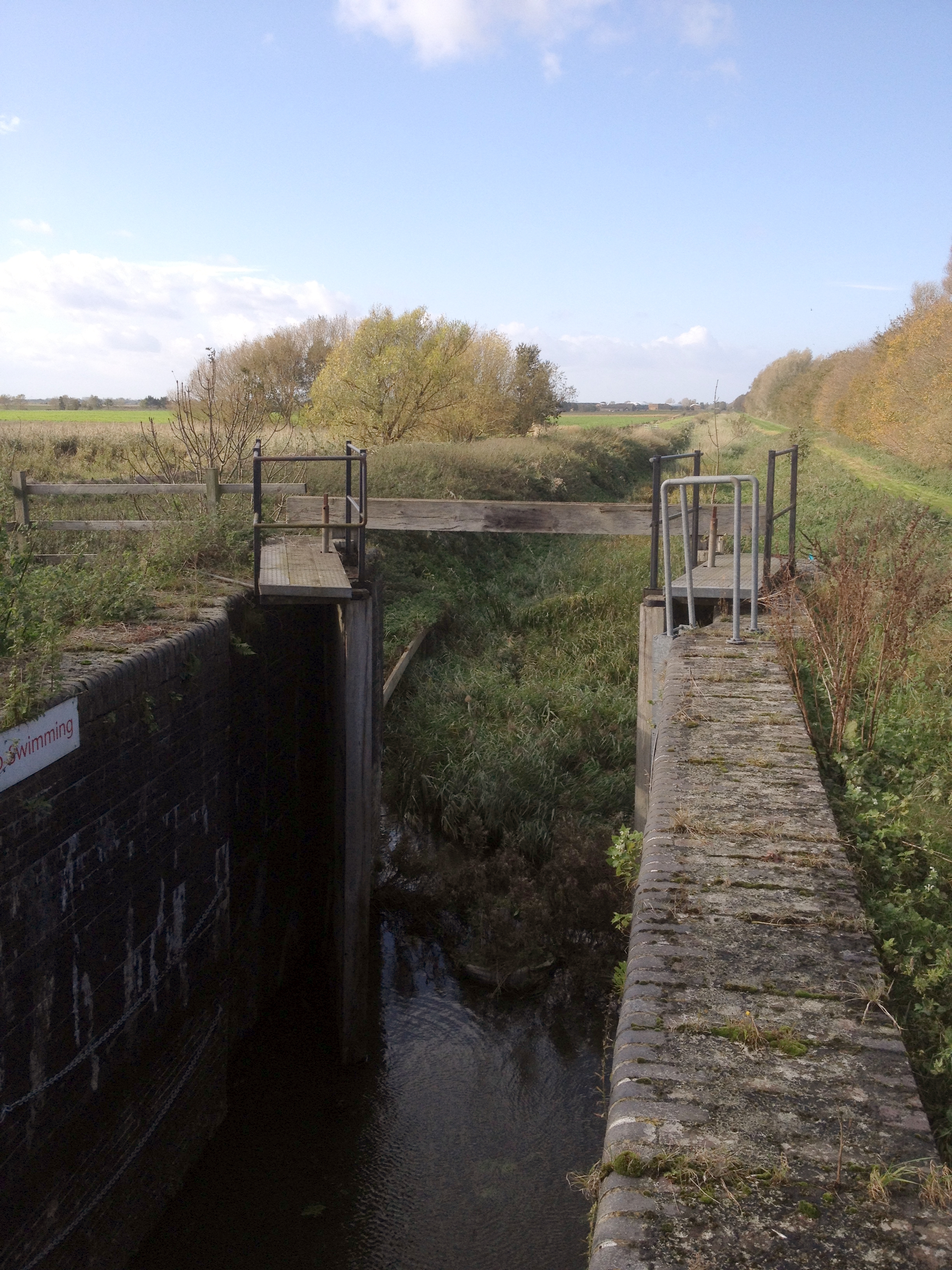 |
|
|
|
Post by NigelMoore on Aug 5, 2018 18:42:54 GMT
The "no swimming" signage seems redundant under the circumstances.
|
|
Deleted
Deleted Member
Posts: 0
|
Post by Deleted on Aug 5, 2018 19:16:46 GMT
Maybe it is a misspelt sign where someone has erroneously added a S and a G to it.
|
|
|
|
Post by TonyDunkley on Aug 5, 2018 20:34:52 GMT
That could be regarded as a cunning and perceptive interpretation - except that is was not on a CaRT waterway. ...... but that evil plan could be regarded as a very real possibility in respect of a certain PRN waterway under the control of another navigation authority: More info here: PROJECT HEREWARD DRONE VIDEOMy memory might be playing tricks with me, but I seem to recall boating along there sometime in the 1950's as a very young boy on a converted ship's lifeboat owned by relatives. My recollections from then are that passage was made difficult, if not almost impossible, by the decrepit condition of the lock chambers, cills and gates and the navigation channel itself was perfectly OK, although very weedy. It looks as if the overall situation has been somewhat stood on it's head, with the chambers and gates now looking to be in a reasonable state but the navigation channel now completely unusable and stanked off. |
|
|
|
Post by erivers on Aug 5, 2018 21:54:05 GMT
Very interesting, Tony. This 3km section of the Forty Foot river between Horseway Lock and Welches Dam (in the picture) was part of one of Vermuyden's first channels dug to drain the Bedford Level in the 1600s. After the Sixteen Foot Drain was extended in the 1800s to provide more effective drainage, the normal retention level of the Middle Level system was lowered. This section was then largely redundant as a main drainage channel and ceased to be the responsibility of the Middle Level Commissioners with control passing to a local drainage board. Eventually that responsibility passed to the Great Ouse River Authority and subsequently on to the Environment Agency in 1996. The waterway has a Public Right of Navigation. The channel west of Horseway Lock and the lock itself remain part of the Middle Level and are maintained by the MLC in good working order. Up until 1976 when Well Creek was finally restored for navigation, the Forty Foot via Welches Dam provided the only navigable link through the Middle Level to the Great Ouse. Many boats used this route to visit the IWA Festival at Ely in 1973 (although the length of Welches Dam Lock at just 47 feet restricted all longer boats). Welches Dam lock was refurbished by the National Rivers Authority and local volunteers in 1991 and although it could be tricky at times due to low water levels, navigation remained possible until 2006. Then, without notice or warning, the Environment Agency unlawfully placed a steel piling cofferdam across the lock entrance at the junction with the Old Bedford River completely preventing navigation by all craft. The reason was subsequently said to be "to prevent loss of water through the leaking gates from entering the Forty Foot from the Old Bedford and flooding of farmland". However, 12-years on it is apparent that the cofferdam is ineffective for its stated purpose (and probably always has been) and it is the lock gates that are still holding back the water. The only purpose of the cofferdam is to prevent navigation. There are problems with leakage of water from the Forty Foot through the underlying gravel, which could potentially seep into the lower surrounding farmland. But this has always been a problem elsewhere in the Fens (particularly the Cambridgeshire Lodes) where lining of the channels as necessary has largely cured the problem. Project Hereward now seeks to independently raise funds to line the Forty Foot as necessary using a modern textile membrane which can be laid without heavy machinery using voluntary labour. Initial surveys indicate that relatively limited work is required to bring the lock back to working order but the ultimate aim is to lengthen it for full-length narrowboats and to re-establish a vital secondary route through the Middle Level and a ML cruising ring. There is a lot of work going on behind the scenes and despite many difficulties and frustrations in dealing with the Environment Agency over the last few years there are signs that subject to satisfactory resolution of some legal issues, progress will be made before too long. Much more (although not quite up to date!) on the PH website: www.project-hereward.org |
|