|
|
Post by Telemachus on Jul 18, 2020 23:32:06 GMT
Notice Alert
Location: River Trent - between Dunham Toll Bridge (Br 32) & Torksey Lock (Lock 1)
Intersection of:
Bridge 32, Dunham Toll Bridge to Bridge 32, Dunham Toll Bridge on River Trent
and
Lock 1, Torksey Lock to Lock 1, Torksey Lock on Fossdyke Canal
Friday 17 July 2020 23:30 until further notice
Type: Navigation Restriction
Reason: Boat damage
Original message:
A boat has become stuck on the tidal section of the River Trent between Dunham Toll Bridge (Br 32) and Torksey Lock (Lock 1) – more specifically between the Ferry Boat Inn and Manor House Park near Church Laneham. The boat is positioned in the middle of the navigation and will therefore restrict the navigation.
River Canal Rescue have been informed and will hopefully be able to remove the craft at some point tomorrow (Sunday 19th July).
|
|
|
|
Post by kris on Jul 18, 2020 23:45:19 GMT
It’s happened a lot recently on the upper Trent as well.
|
|
|
|
Post by JohnV on Jul 19, 2020 7:14:10 GMT
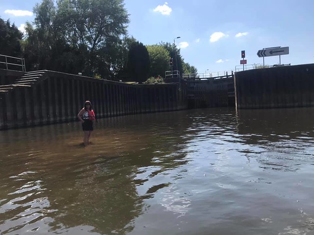
I'm not surprised, I posted a picture a bit ago of a woman standing knee deep in the water by Hazleford lock ....... There is a massive amount of dredging work needed all over the place.
We are not in the EU now and it's about time that ludicrous clasification of dredgings as hazardous waste was changed.
|
|
|
|
Post by TonyDunkley on Jul 19, 2020 7:19:29 GMT
Until checking just now on C&RT's webshite, I was inclined to think that this was some sort of joke, . . but no, it's all there, word for word, . . and yes, a run of the mill grounding in a tidal river HAS been reported as - "Boat Damage".
The Notice went out timed at 2330 hrs on Friday 17 July, so presumably the boat in question grounded at or around local High Water, . . which made just under 3' in the river at Torksey and would have been at around 2040 where the boat grounded. The location is undoubtedly the shoal that North Beck pushes across the river at Maltkilns, about 300-400 yards lowside of Laneham Ferry. The Notice states that - "The boat is positioned in the middle of the navigation and will therefore restrict the navigation." - which is utter twaddle, because the deepest water is nowhere near the middle of the river just there.
It will be interesting to see how RCR get on with today's re-floating attempt. HW at Maltkilns will be shortly after 1000 hrs this morning, and if up to prediction, should make a good 6" more than the tide the boat grounded on.
I wonder who will be picking up the bill for RCR's totally unnecessary participation ?
|
|
|
|
Post by kris on Jul 19, 2020 7:46:09 GMT
I wonder who will be picking up the bill for RCR's totally unnecessary participation ? I’m sure cart will, try to get the boater to pay. When I “grounded,” my boat they told me to phone rcr. I just laughed and told them they had misunderstood and that I’d phoned them because I was putting a chain across the navigation and pulling myself off. |
|
|
|
Post by Telemachus on Jul 19, 2020 9:22:28 GMT
Apart from the bits near the locks and any wharves etc, would the tidal trent have been routinely dredged in the past eg the section where this boat grounded? Or is it just a case of this boat being in the wrong bit of water (not on the outside of the bend, or whatever).
|
|
|
|
Post by JohnV on Jul 19, 2020 16:56:42 GMT
|
|
Deleted
Deleted Member
Posts: 0
|
Post by Deleted on Jul 19, 2020 17:10:14 GMT
Apparently all the lock keepers are now finishing at 3pm not 5pm and no lock keepers on the tidal locks unless booked, although you were supposed to book they were often there anyway.
|
|
|
|
Post by kris on Jul 19, 2020 17:26:04 GMT
cart best start investing in some kind of dredging or shortly no boats are going to be moving any where. |
|
|
|
Post by JohnV on Jul 19, 2020 17:42:49 GMT
Apparently all the lock keepers are now finishing at 3pm not 5pm and no lock keepers on the tidal locks unless booked, although you were supposed to book they were often there anyway. Which locks have you got that about ? .... it's certainly not the case at Naburn .... the finish time for the lock on Thursday was 10pm (Start 3pm)
|
|
Deleted
Deleted Member
Posts: 0
|
Post by Deleted on Jul 19, 2020 17:51:33 GMT
|
|
|
|
Post by JohnV on Jul 19, 2020 18:22:02 GMT
lock keepers of Naburn, West Stockwith and Torksey often rotate ..... not certain about Cromwell
As far as I know they are lock keepers not vollockies as there was huge opposition to vollockies due to the hazardous nature of the navigation.
You always have "booked" warning the lockie of your likely time of arrival but that has always been a courtesy not a requirement and often more to find the shift times
You have to have staggered shifts at tidal locks as a fixed time operation might result in no safe navigation is possible
|
|
|
|
Post by TonyDunkley on Jul 20, 2020 7:54:47 GMT
Apart from the bits near the locks and any wharves etc, would the tidal trent have been routinely dredged in the past eg the section where this boat grounded? Or is it just a case of this boat being in the wrong bit of water (not on the outside of the bend, or whatever). In answer to the dredging question first, . . yes, the 26 miles of the Trent from Cromwell Lock to Gainsborough was routinely dredged, with a bucket dredger permanently allocated to and working on that section of river. Natural scouring by the Ebb plus run-off water, assisted by the passage of loaded commercials, kept the navigation channel deep and clear for the majority of those 26 miles and the dredger was stationed for lengthy periods at spots where waterborne sediment consistently settled out due to reductions in the speed of the current brought about by changes in the river's cross-section and bed profile. During each lengthy spell at these locations a wide, deep hole was dredged out to act as a reservoir for the material which the river would deposit there prior to the return of the dredger several months later. As for the stranded boat reported in the 17 July Notice, it was stated to be grounded midstream at Maltkilns, so no, it wasn't anywhere near the natural deep channel the Ebb and run-off water creates where North Beck runs into the Trent and deposits large amounts of silt and sand into the slow bight lowside of Laneham Ferry. The deepest water there is, and always has been, well over to the ness on the eastern bank. |
|